by Anne Mooney | Dec 5, 2019 | Custom Author, Headline, Orange Avenue Overlay, Zoning and Development
Orange Avenue on Track to Become Hot Spot
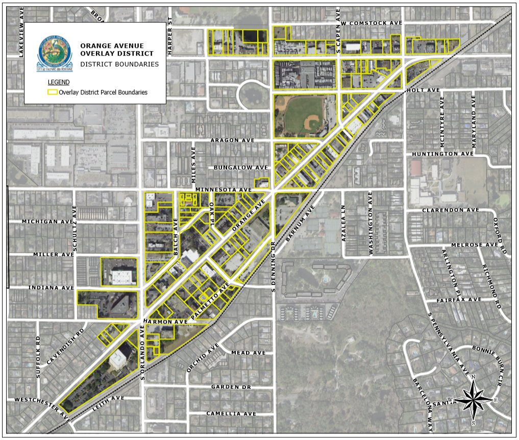
December 5, 2019 / by Geri Throne
A 40,000-square-foot lakefront home proposed for Palmer Avenue—the biggest home ever in the city—is garnering the most attention outside Winter Park. But residents who crowded a city planning and zoning board meeting Tuesday had an even bigger issue on their minds: a rezoning plan to convert North Orange Avenue into the city’s next intensely developed hot spot.
After a long line of residents spoke for and against the rezoning proposal, members of the advisory board all voiced their enthusiastic support. They agreed that benefits would outweigh any negatives and voted unanimously to recommend the proposal to the city commission.
City commissioners will consider the rezoning plan at its Jan. 13 meeting.
Planning jargon aside…
Despite use of planning jargon such as “overlay district” and “placemaking” at Tuesday’s hearing, the issues surrounding the proposed Orange Avenue district boil down to familiar zoning concerns: Is growth “inevitable” in Winter Park, and if it is, how much development should be packed into an area? How high should buildings be allowed? How much extra traffic should be created? How well would new construction mesh with existing structures?
City Planning Director Bronce Stephenson said a flexible mixed-use overlay is the best way to deal with the avenue’s future growth. He defended the months-long process the city went through to arrive at the proposal, noting that residents were involved early on. An 11-member appointed steering committee, made up of people with broad ranges of opinion about development, participated in the recommendations.
“Despite what has been reported [in social media], the small-scale character of Orange Avenue has been promoted and protected throughout the process to the highest extent possible,” Stephenson said.
Residents concerned about the new zoning district, however, were not convinced. They asked the planning board for more time to digest the thick packet explaining the proposal. They noted the potential for congestion, more traffic and buildings as tall as five and seven stories within the district.
Although the number of residential units in the district would stay the same, total development in the proposed district would become more intense. Under current zoning, almost 1.9 million square feet of development is possible in the district. With the new district zoning, the total square footage possible would climb to more than 2.6 million.
The debate…
The benefit, Stephenson said, would be a mixed-use plan that would improve the area visually, attract more visitors, and cure what the city sees as “economic stagnation” on Orange Avenue from Fairbanks Avenue to US 17-92. Some other pluses he cited: wider, safer sidewalks; more open space; connection with nearby Mead Botanical Gardens, and parking garages set back behind buildings. Design standards would ensure that new structures would be attractive and compatible with neighboring buildings.
Existing zoning also would allow more development, he said, and perhaps not what residents might desire. Without new and creative zoning, he warned, a Wal-Mart-sized structure could be built with a huge paved parking lot.
Some residents, however, worried that the plan didn’t do enough to honor the city’s stated commitment to cherish “its traditional scale and charm.” Resident Bart Johnson said that exceptions to that goal in most of the proposed district were big enough for a developer to “drive a truck through.”
“Citizens need more time to fully understand the implications” of the lengthy new ordinance, pleaded resident Pat McDonald, a concern echoed by other residents.
Frank Hamner, an attorney representing the Holler family, a major property owner in the area, criticized calls for further delay as having “a different purpose” than stated. Residents had ample time to attend the numerous public meetings about the proposal, he said. Their calls for more time were “a distraction” to “delay for delay’s purposes.” Hamner also accused unidentified people of posting online anonymously and knocking on doors “spreading lies” about the plan. Those people should “come up out of the sewer,” and make their case face to face, he said.
Traffic worries
Stephenson downplayed traffic worries. The planning director stressed that the overlay is a “framework” or starting point, which must be approved before a traffic study can be done. He also cited a state study that found few drivers stopped on Orange Avenue as a destination. He described it as a “cut through” road.
That four-lane stretch of North Orange Avenue is no shortcut, however. It serves as an arterial road in Winter Park, connecting Winter Park commuters to State Road 527 and US 17-92 and helping them get from one side of the city to the other. Traffic accidents on that stretch are frequent, city statistics show. Until a traffic study is conducted, it remains unknown how traffic safety, street parking and traffic flow will be juggled under the proposed design.
Left unknown…
Undecided in the proposed ordinance is the fate of Progress Point, an odd-shaped, city-owned parcel at the intersections of Orange Avenue and Denning Drive. The steering committee could not agree how the lot should be used or whether the city should sell it. Sheila Deciccio, a member of that steering committee, urged that the city keep the land, which might help solve area stormwater and parking problems. The site is “one of the jewels we have left,” she said.
Also unknown, but probably not in doubt, is an unrelated agenda item—the fate of the massive 40,093-square-foot home that real-estate developer Marc Hagle wants to build on Lake Osceola. The planning and zoning board tabled its vote until next month after some board members and two neighbors raised questions about a proposed setback.
To comment or read comments from others, click here →
by Anne Mooney | Nov 21, 2019 | Headline, Orange Avenue Overlay, Zoning and Development
What is an Overlay District?
What Does It Mean for the Orange Avenue Corridor?
Back in 2016, the Commission added a provision to the City’s Comprehensive Plan promising the creation of a “Mixed Use Overlay” category ‘within one year.’
Now that we are finally getting around to it, what is it anyway?
‘Mixed Use’ is a development term – a type of development Winter Park has done before on Park Avenue and in Hannibal Square that includes commercial, retail and residential development. Some would include Winter Park Village in that category, though the residential component is less apparent. The rules for these specific areas have worked well for us. That’s why Park Avenue and Hannibal Square look the way they do and why they have stood the test of time.
Asked what happens if a developer just follows regular City zoning regulations instead, Planning Director Bronce Stephenson responded, “Trader Joe’s.”
What is happening on Orange Avenue is a mixed use zoning overlay, but you can call it ‘mixed use,’ an ‘overlay district’ – or baked potatoes. Simply put, a zoning overlay regulates development within certain geographical boundaries in a manner that expresses the community’s vision of what they want the area to be. In this case, it also is way of granting entitlements to developers that seems fairer to the City.
What ‘City’?
Parenthetically, this brings us to a thought to keep in mind during this discussion: Who or what is The City? Is it you and me and everyone who lives here and pays taxes? Is it the elected officials who sit on the dais? Is it the staffers who toil behind the scenes to make the machinery work? Is it all of the above?
In the case of the Orange Avenue project, the answer is ‘all of the above.’ In April, the [then new] Director of Planning and Community Development, Bronce Stephenson, brought together a Steering Committee of 11 citizens from across the political spectrum to create a vision for what the Orange Avenue corridor should be. The Committee met 12 times over the summer. Public input was taken at each meeting.
The Steering Committee and staff identified a specific geographic area, divided it into sub-areas depending upon the type of development that was either existing or possible, and decided how they thought the area could develop in a way that would preserve the eclectic character and offer the greatest benefit to The City. The area they defined became the Orange Avenue Overlay (OAO) area.
Three large landowners – Demetree Holdings on the southern part of Orange Avenue, Holler Properties on Denning and Fairbanks, and City-owned Progress Point in the middle – all have holdings that are large enough to be able to provide resources to upgrade the entire corridor for The City.
The Problem
To fix area-wide issues that affect existing businesses and discourage redevelopment within the OAO district, staff and the Steering Committee first had to identify the problems. What they found won’t surprise anyone.
- • Dangerous and inefficient traffic flow
- • Archaic one-size-fits-all zoning codes
- • An approximately 485-space parking deficit – before a single new thing is built
- • Poor storm water management that causes businesses on Orange Avenue to flood.
The Fix
The OAO seeks to grant entitlements to developers by ‘quid pro quo’ rather than by variance or rezoning. If a developer is granted entitlements by rezoning and/or variance, as is currently the norm, the developer gets some or all of what he or she wants . . . and the City gets little if anything in return.
Give . . .
According to the rules being put in place for the OAO, if the developer has an ‘ask,’ the developer must also bring a ‘give.’ City Planning Director Bronce Stephenson explained that a developer can offer two kinds of ‘gives’ – quantitative and qualitative.
Qualitative gives might include:
- • Safety & mobility
- • Life, light and eyes on the street
- • Connectivity
- • Better traffic flow
- • Storm water management
Quantitative ‘gives’ could include:
- • Shared parking
- • Storm water treatment and management
- • Meaningful open space with unrestricted public access
- • Trails and other mobility enhancements
Of course, there would be overlaps.
. . . and Take
Doors and Keys – for which read: density — pay for storm water mitigation, parking & open space. If developers don’t make money on their projects, they don’t do them. Eliminating parking from Floor Area Ratio (FAR) calculation is one way to help them be profitable. Large owners – Demetree, Holler and the developer of Progress Point – will be able to ‘earn’ up to 200 percent FAR by providing fixes for one or more of the area-wide problems. The 200 percent FAR is what we have on Park Avenue and in Hannibal Square.
Storm Water Treatment
“We are desperate for space for storm water treatment, especially along Orange Avenue,” said Stephenson. “Progress Point is the lowest elevation within the OAO, and that provides an opportunity for the developer of that property to correct the flooding and storm water treatment problem for the entire area.”
Parking
“Today’s 485-space parking deficit translates into 3.9 acres of asphalt surface parking,” Stephenson explained. “We want developers to come in and build vertical parking with 10 percent additional shared spaces. There’s not enough room for it to be surface parking. That means, to make their developments work, the parking places should not be included in their FAR calculations.”
Open Space
Developers with properties larger than 1.5 acres must provide 25 percent “meaningful open space.” For the Holler property, at the current asking price, that 25 percent translates to $6 Million worth of land, according to Stephenson – a sizeable ‘give’ in anyone’s estimation.
Give And Take
Described here are just some of the concessions from developers that will provide substantial value to The City as the OAO redevelops. The final draft report of the Steering Committee will provide detailed lists of ways developers can earn entitlements. Information regarding the Committee’s progress is updated regularly on the City website https://cityofwinterpark.org/government/boards/orange-avenue-overlay-steering-committee/.
What About Progress Point?
The Steering Committee, with 10 of its 11 members present, met the night of November 13 at the Mead Botanical Garden Clubhouse to vote on the final report. As the final report was presented, the one remaining bone of contention was the four-acre parcel at Progress Point.
The City owns the land, but will either lease or sell to a third party to develop the parcel. Over the 12 Steering Committee meetings, there had been considerable discussion of a four-story office building with associated parking structure, but a number of Steering Committee members were unhappy with that solution.
Stephenson pointed out that while The City has no pressing need to sell or lease this piece of land, it has not proven itself to be a good steward. The Committee members agreed that what we need at that location is parking, open space, drainage and connectivity with Mead Garden.
Devoting the entire 4+ acres to parkland would deprive the existing Orange Avenue businesses of the opportunity for treatment of storm water that currently floods many of their businesses, and it would deny them desperately needed parking.
No Consensus on Progress Point
At the end of the day, the Steering Committee stipulated in their report that there was no consensus on the use of Progress Point. The Committee voted 8 – 2 to approve the final report. Dissenting were Michael Dick and Sheila DeCiccio.
“We Can Do Better”
Asked why she voted against the report, DeCiccio stated, “I wanted my voice to be heard on Progress Point. I am 100 percent for everything else in the report. I am all for the Holler and Demetree entitlements. But a four-story office building with a garage bigger than the new one at Rollins? We can do so much better than that.”
“Most of what’s there now is already offices and daytime use,” DeCiccio went on. “There can’t be any shared parking in the daytime – they don’t have enough daytime parking as it is, and nothing much goes on there at night. An office building will not contribute anything there.
“There are so many wonderful things we could do there that would activate the area at night,” she said. “We could do a theatre district, food courts, things that people could go to and have fun. We can do more than just green park space, too, but we wouldn’t need so much parking if we put something besides an office building there. Where is our imagination? This is Winter Park – we need something really wonderful for everyone there.”
There is No Lack of Public Input
By the end of this process, the City will have held 19 opportunities for public input.
The Steering Committee Report will go to Planning & Zoning December 3 for a public hearing.
A public information meeting will be held at Gateway Plaza lobby (Commerce National Bank) on December 18, 5:30 – 7:30 pm.
City Planning Director Bronce Stephenson will be at the Farmer’s Market December 21 from 7:00 am to 1:00 pm to answer questions.
You can watch three educational videos about this process at cityofwinterpark.org/vimeo
And you can email your feedback to OrangeAve@cityofwinterpark.org
To comment or read comments from others, click here →
Recent Comments